
Torres del Paine is Patagonia’s trekking capital: the 4-5 day W Trek (1,400-4,000 USD) and the wilder 8-9 day O Circuit (800-3,000 USD, capped at 70 hikers/day) are the two flagship routes. El Chaltén adds free-access trails facing Fitz Roy, while Perito Moreno’s advancing glacier and the Carretera Austral’s 1,200 km road trip round out a complete trip. Budget 15 days and 3,500-6,000 USD (excluding flights), and book refugios 4 to 6 months ahead — the cheapest spots have historically sold out by May for the following season. First-timers: start with the W Trek.
Patagonia is the last great wilderness on Earth. Beyond the 42nd parallel south, straddling Chile and Argentina, lies a world of granite towers, perpetually moving glaciers, and steppes swept by winds fierce enough to topple guanacos. In 2026, Torres del Paine remains the mythical epicenter of South American trekking — but Patagonia is also Fitz Roy ablaze at dawn, a Perito Moreno glacier that advances while all others retreat, the Carretera Austral and its legendary 1,200 km road, and the Dientes de Navarino, the most southerly trek on Earth. Here is the complete guide — sourced, illustrated, and lived — to plan your adventure at the end of the world. Allow a minimum of 15 days, a budget of 3,500 to 6,000 USD (excluding intercontinental flights), and above all: book early.
1. The W Trek of Torres del Paine — The Must-Do
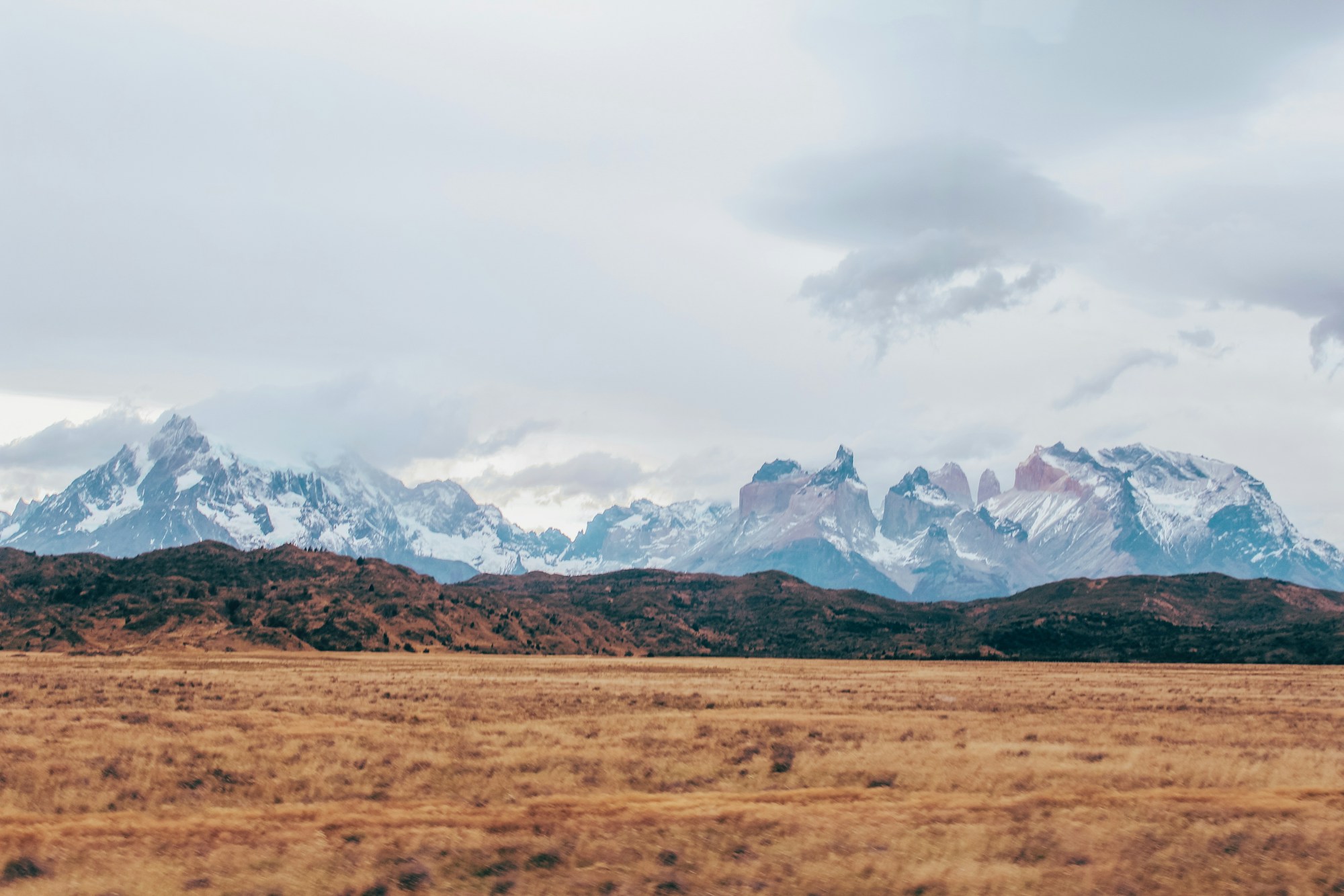
Torres del Paine National Park — Chilean Patagonia
The W Trek winds through the heart of Torres del Paine National Park, a land where granite towers soaring above 2,800 meters dominate lakes of an unreal turquoise blue. The trek takes its name from the « W » shape it traces on the map, successively ascending toward the base of the Torres, the Valle del Francés, and Grey Glacier. Of moderate difficulty, it requires no technical climbing skills but demands long days of hiking under unpredictable weather, as noted by Explorer’s Passage. In the height of the austral summer, you’ll enjoy 15 to 17 hours of daylight per day — a luxury for photographers and early-bird hikers.
Park entrance fees are 35 USD in high season (November to March) and 18 USD in low season, according to the 2026 UNESCO guide. The total cost varies considerably: expect around 236 USD per person for self-supported camping (tent and food included), but up to 4,000 USD if you opt for refugios with full board — a hut-based trekking style comparable to hut-to-hut hiking in the Alps and Dolomites, as detailed by Worldly Adventurer. The approach to Grey Glacier, along the namesake lake dotted with icebergs, is one of the trek’s most breathtaking moments — you’ll get within touching distance of one of the most pristine parts of the park.
A crucial warning: all overnight stays must be booked in advance, without exception. In 2025, some Las Torres campsites were fully booked by May for the following season, and reservations for the 2026-2027 season (November 2026 to March 2027) are following the same early-sellout trend. TorresHike recommends booking your spots 4 to 6 months before departure, as soon as reservations open. The cheapest spots sell out first — waiting even a few days may leave you with only the most expensive options, or nothing at all.
Highlights of the W Trek
- Sunrise over the Torres — the iconic image of Patagonia
- Valle del Francés — granite amphitheater surrounded by hanging glaciers
- Grey Glacier and its blue-tinted icebergs floating on the lake
- 15–17 hours of daylight in summer for epic hiking days
- Moderate accessibility — no technical climbing required
2. The O Circuit of Torres del Paine — The Wild Loop
Torres del Paine National Park — The Full 126 km Loop
The O Circuit is the raw jewel of Torres del Paine National Park. This 126-kilometer loop encompasses the entire W Trek then circles behind the Cordillera del Paine massif, where most hikers never venture. As Backcountry Emily explains, the O Circuit takes you « beyond the crowded W Trek, to the remote side of the park, where you’ll cross the spectacular John Gardner Pass and camp beside turquoise lakes and breathtaking glaciers. » It’s a trek for experienced hikers seeking isolation and total immersion.
Since 2017, visitor numbers have been limited to 70 per day on the back portion of the circuit, making it a surprisingly peaceful route for such a famous park, according to Worldly Adventurer. Crossing John Gardner Pass (1,241 m) is the climactic — and most demanding — moment of the trek: a steep descent facing the Campo de Hielo Sur (Southern Ice Field), the third-largest ice cap in the world. Costs vary greatly: Vertice Patagonia campsites charge between 12 and 14 USD per person per night, while Las Torres refugios run between 40 and 90 USD, according to the O Circuit campground guide.
A vital warning: on November 17, 2025, a blizzard with 190 km/h winds — comparable to a Category 3 hurricane — killed five hikers at John Gardner Pass, as reported by Worldly Adventurer. The circuit closed until December 2025 and briefly required a licensed guide; CONAF has since lifted that requirement and rolled out an updated safety protocol with earlier weather-based trail closures. This crossing can still be deadly in bad weather. Always check the weather forecast on Windy before attempting this pass, and never hesitate to wait for a calmer window.
Highlights of the O Circuit
- John Gardner Pass — sweeping view over the Southern Ice Field
- Maximum 70 visitors/day on the back portion — guaranteed solitude
- Pristine Magellanic forests and wildlife (condors, guanacos, pumas)
- Includes the entire W Trek + the back of the massif
- The most complete trek in all of Torres del Paine
3. El Chaltén & Mount Fitz Roy — The Free Trekking Capital
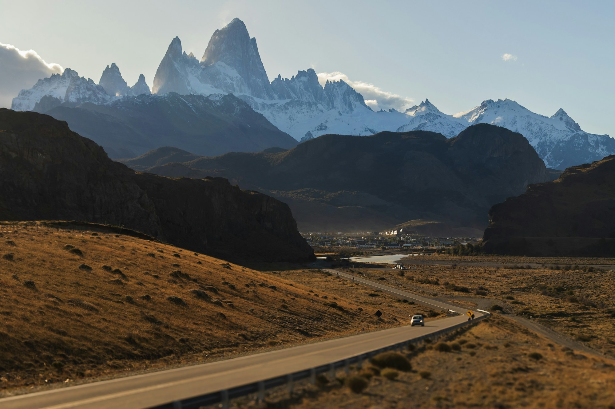
El Chaltén — Los Glaciares National Park, Argentina
El Chaltén is a village of fewer than 2,000 permanent residents, nestled at the foot of Fitz Roy in Los Glaciares National Park — and it’s probably the best value for money in all of Patagonia. Why? Because access to all trails is completely free, with no permits or entrance fees, according to the official 2026 guide. You simply register for free at the National Park office (Avenida Guemes) in 5 to 10 minutes to get current trail conditions. The network of over 100 kilometers of maintained trails starts directly from the village center — no costly transfers needed. Most international flights connect through Buenos Aires before reaching El Calafate’s airport, the gateway to both El Chaltén and Perito Moreno — a good excuse to build in a stopover for La Boca’s tango halls and street art before or after your trek.
The peak that inspired the Patagonia brand logo is right here, and it does not disappoint. The trek to Laguna de los Tres (22 km round trip, 750 m elevation gain) offers the most iconic view: Fitz Roy (3,405 m) ablaze with the alpenglow of sunrise, its granite spires reflected in the turquoise waters of the glacial lagoon. Further south, the trail to Cerro Torre passes through lenga forests and ends at Laguna Torre, facing the most technical and controversial spire in Patagonia. Accommodation in El Chaltén starts at 40 USD per night, compared to 60 to 120 USD in El Calafate, according to Machu Picchu Travel Tips.
El Chaltén also offers more accessible hikes: Chorillo del Salto (a waterfall 4 km from the village), Mirador de los Cóndores (panoramic view in 1 hour), and Laguna Capri (an ideal viewpoint for a sunset over Fitz Roy without the effort of Laguna de los Tres). The village itself, with its craft breweries, Patagonian lamb restaurants, and laid-back mountain atmosphere, deserves a day or two of rest between hikes, according to Minimalist Journeys.
Highlights of El Chaltén
- 100% free access to over 100 km of trails — unique in Patagonia
- Laguna de los Tres — sunrise over Fitz Roy (the Patagonia logo!)
- Laguna Torre — facing Cerro Torre and its namesake glacier
- Authentic village with breweries, restaurants, and mountain vibes
- Lowest budget in Patagonia: 15–35 EUR per day all-inclusive
4. Perito Moreno Glacier — The Ice That Advances
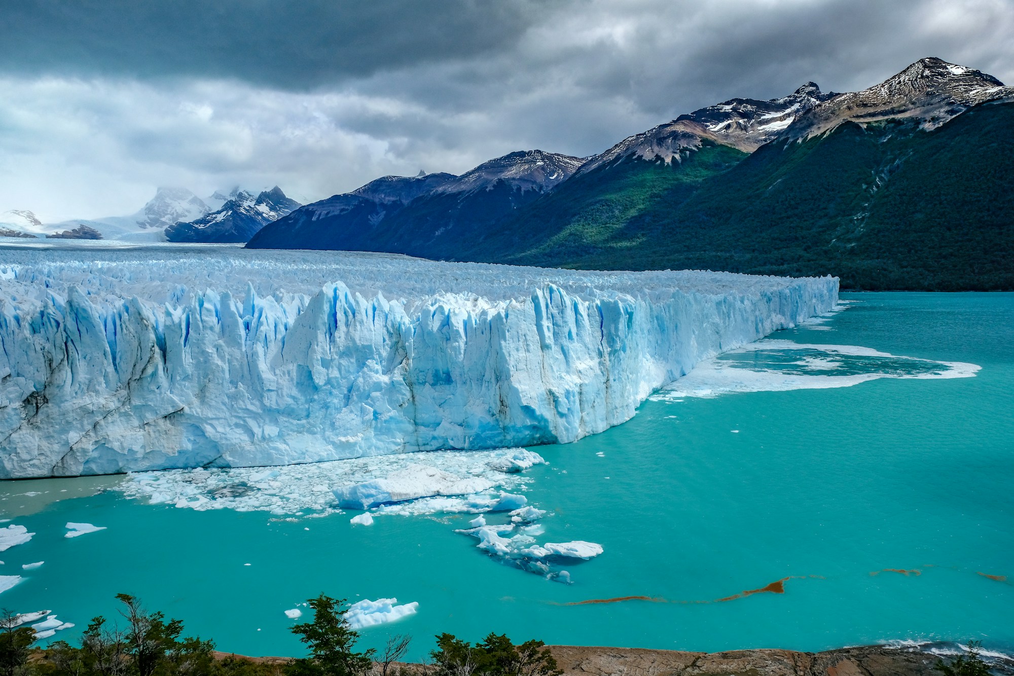
Perito Moreno — Los Glaciares National Park, El Calafate
Perito Moreno is one of the few glaciers in the world that continues to advance while the vast majority of its counterparts retreat under the effects of climate change. Its front stretches 5 kilometers wide and rises 70 meters high — the total surface area could contain the entire city of Buenos Aires, according to Sol Salute. The spectacle is constant: immense blocks of ice break away from the wall with a thunderous crack and crash into Lago Argentino, generating waves that reach the observation walkways. This is the phenomenon of calving, and Worldly Adventurer describes it as « one of nature’s most stunning spectacles. »
Two main experiences await you. The first, the walkways, is accessible to everyone: a network of wooden platforms facing the glacier (park entrance + transport: 70 to 100 USD). The second, minitrekking, is an immersive experience where you walk directly on the ice with crampons for about an hour and a half — expect to pay between 250 and 320 USD, guide and equipment included, according to Daytours4u. For a tight budget, Journey by Backpack advises booking directly with Hielo y Aventura at their El Calafate office: prices in Argentine pesos can be significantly lower than the dollar prices shown on online platforms.
Unlike Torres del Paine or El Chaltén, Perito Moreno is accessible without any particular physical fitness. It’s an ideal stop for a rest day between two treks, or for non-hiking companions. The 2026 UNESCO guide recommends the shoulder seasons (April-May or September-November) for accommodations 30 to 50% cheaper and fewer crowds, while maintaining excellent viewing conditions.
Highlights of Perito Moreno
- One of the few advancing glaciers in the world — guaranteed calving spectacle
- Minitrekking on the ice with crampons (250–320 USD all-inclusive)
- 5 km wide and 70 m high front — staggering dimensions
- No fitness requirements — perfect between two treks
- UNESCO World Heritage Site
5. Cerro Castillo — The Secret Alternative to Torres del Paine
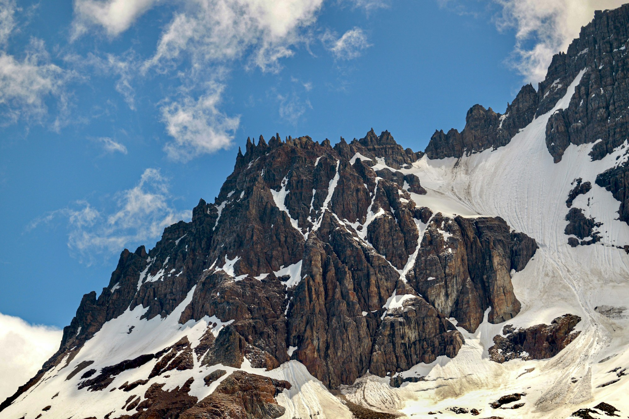
Cerro Castillo National Reserve — Carretera Austral, Chile
If Torres del Paine is the king, Cerro Castillo is the crown prince — and whispers in the trekking community predict it will soon claim the throne. Open to trekking only since 2017, this park on the Carretera Austral offers basalt spires, hanging glaciers, and milky-blue lagoons that easily rival the landscapes of Torres del Paine, but without the crowds and without mandatory reservations. As Six Pieds sur Terre describes, « the trails are newer, the atmosphere wilder, the experience sometimes more demanding. »
The 4-day circuit passes through vast forests of Tierra del Fuego beech trees (lengas in Spanish), offers magnificent views of Cerro Castillo and its glaciers, and overlooks the northern sector of Lake General Carrera. Remarkably, the park is home to a population of huemules, the elusive endangered Andean deer featured on Chile’s coat of arms, with sightings reported near the trails, according to Swoop Patagonia. Park entrance costs only 20,000 Chilean pesos per person, and the trailhead is less than 5 km from town — accessible even by hitchhiking, according to Generation Voyage.
The Las Horquetas Trek, a longer 6-day variant, crosses wild terrain of alpine meadows and river valleys where human presence is even rarer. Swoop Patagonia calls it a « hidden gem of Patagonian trekking. » Here, there are no cabanas, no refugios — just CONAF campsites at 8,000–15,000 pesos per night and pure Patagonian wilderness.
Highlights of Cerro Castillo
- Alternative to Torres del Paine without crowds or mandatory reservations
- Possible huemul sightings — an endangered deer species
- Basalt spires and milky-blue glacial lagoons
- Very affordable: ~22 EUR entrance + budget campsites
- Open since 2017 — still largely unknown to tourist circuits
6. The Carretera Austral & Glaciar Exploradores — The Legendary Road
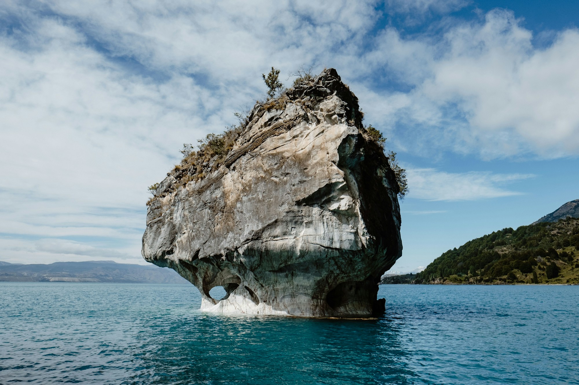
Route 7 — 1,200 km from Chaitén to Villa O’Higgins, Chile
The Carretera Austral is to Patagonia what Route 66 is to the United States: a myth on asphalt (and often on gravel). Over 1,200 kilometers, Chile’s Route 7 crosses one of the most remote and preserved areas on the continent — from snow-capped volcanoes to deep fjords, from Valdivian rainforests to hanging glaciers. National Geographic ranks it among the most beautiful road trips in the world, and not without reason: « glacial waterfalls, tropical plants, dolphins, marble caves — the Carretera Austral is an explorer’s paradise. »
The must-see stop is at Puerto Rio Tranquilo: the Marble Chapels (Capillas de Marmol), a network of caves veined with blue streaks sculpted in calcium carbonate by over 6,000 years of hydraulic pressure. You explore them by kayak or boat on the translucent waters of Lake General Carrera, the second-largest lake in South America. Further south, Glaciar Exploradores offers one of the most affordable glacier treks in Patagonia: starting at 150 USD per person for 5 to 7 hours of trekking on ice, crampons and helmet provided, according to Argentina Pura — half the price of minitrekking on Perito Moreno.
At the northern end of the road, Queulat National Park offers a surreal spectacle: a hanging glacier (Ventisquero Colgante) clinging to a cliff face, from which glacial waterfalls cascade down. Further south, the road ends at Villa O’Higgins, an isolated hamlet from which you can take a boat across Lake O’Higgins to admire O’Higgins Glacier — according to Sally Sees, « a 3-week road trip on the Carretera Austral, between camping by crystal-clear rivers and hiking through lush forests, is an immersion in pristine, wild nature. »
Highlights of the Carretera Austral
- Marble Chapels — caves sculpted over 6,000 years
- Glaciar Exploradores — ice trek from 150 USD (half the price of Perito Moreno)
- Queulat Hanging Glacier — glacial waterfall on a cliff face
- 1,200 km of ever-changing landscapes — volcanoes, fjords, forests, and glaciers
- Far from the Torres del Paine crowds — authentic adventure
7. Ushuaia & Tierra del Fuego — The End of the World
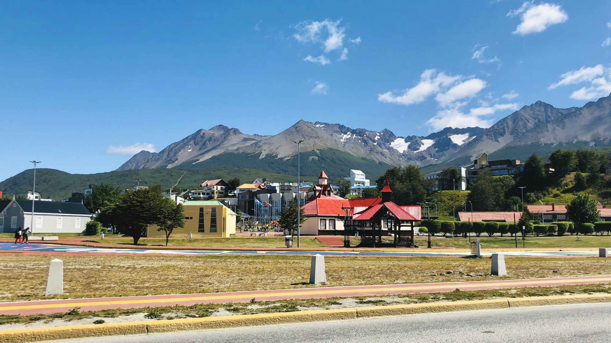
Ushuaia — Tierra del Fuego Province, Argentina
Ushuaia proudly bears its title of « the southernmost city in the world » — and it deserves it. Nestled between the snow-capped mountains of the Darwin Range and the cold waters of the Beagle Channel, which stretches over 200 kilometers from the Atlantic to the Pacific, this city of 60,000 is the gateway to Tierra del Fuego. The channel has a remarkable distinction: it is the largest ship graveyard in the world, as noted by Terres des Andes. In the austral summer, days exceed 17 hours of daylight — a considerable asset for exploring the surrounding trails and fjords.
Tierra del Fuego National Park (entrance ~40 USD) offers accessible hikes along the coast and through sub-Antarctic forest, but it’s Cerro Guanaco that steals the show. This intense trek crosses peat bogs then climbs steep sections to emerge at an unmatched panoramic viewpoint: the park, its lakes and lagoons, Ushuaia, the Beagle Channel, and the entire Darwin Range, according to Bucketlist Aventure. The Darwin Range itself is one of the most secret and inaccessible massifs in Patagonia — some specialized operators have been guiding confidential expeditions there by kayak or on foot for nearly 20 years, as mentioned by Terres Oubliees.
Beyond hiking, Ushuaia is also the departure point for Beagle Channel cruises to observe colonies of Magellanic penguins, sea lions, and cormorants, as well as the gateway to Antarctica for cruise passengers. The Maritime Museum, housed in the former prison at the end of the world, tells the fascinating history of convicts and explorers. And for food lovers, don’t miss the centolla (king crab) fished from the channel — the city’s signature dish.
Highlights of Ushuaia
- Cerro Guanaco — 360° panorama over the Beagle Channel and Darwin Range
- Beagle Channel — cruise with penguins, sea lions, and cormorants
- Darwin Range — confidential expeditions by kayak or on foot
- Over 17 hours of daylight in summer — endless days at the end of the world
- Gateway to the Dientes de Navarino via ferry to Puerto Williams
Frequently Asked Questions
When should I book the W Trek or O Circuit at Torres del Paine for 2026?
Book your refugio accommodations 4 to 6 months in advance for high season (December-February). In 2025, all Las Torres camping spots were sold out by early May for the following season. The exact opening date for reservations is not precisely announced, but the trend is to move it earlier each year. If you’re on a tight budget, the cheapest campsites and dorm beds always sell out first — book on the very first day reservations open.
What is the difference between the W Trek and the O Circuit?
The W Trek covers approximately 80 km in 4-5 days and traces a « W » shape through the most iconic sites (Torres, Valle del Frances, Grey Glacier). The O Circuit (126 km, 8-9 days) includes the entire W plus a loop around the back of the massif, with John Gardner Pass and the Campo de Hielo Sur. The O is significantly harder and limited to 70 visitors per day on the back portion, which guarantees unparalleled solitude. The W suits intermediate hikers; the O requires excellent physical fitness and solid bivouac experience.
Is a guide mandatory for these Patagonian treks?
No for the W Trek and El Chaltén — most hikers do them independently, provided they are well prepared and have booked accommodations in advance. Strongly recommended for the O Circuit (John Gardner Pass is dangerous in bad weather) and virtually essential for the Dientes de Navarino — the trail is unmarked for much of the route, and the weather is among the most unpredictable in Patagonia. For Cerro Castillo and Glaciar Exploradores, a guide is not mandatory but guided tours include technical equipment (crampons, helmet).
What is the best weather app for Patagonia?
The Windy app is by far the most reliable for Patagonia. It displays wind, rain, temperature, and storm systems on a single screen. This is particularly crucial before crossing John Gardner Pass (O Circuit) or for planning sunrise at Fitz Roy. Note: there is no cell coverage inside Torres del Paine National Park — check the forecast before entering the park and download offline maps.
Is El Chaltén really free for hikers?
Yes! No permits are required and access to all trails is completely free in 2026. Los Glaciares National Park maintains free access to the trails around Fitz Roy and Cerro Torre. You simply register for free at the National Park office (Avenida Guemes) in 5 to 10 minutes to get current trail conditions and safety information. It is one of the most accessible world-class trekking destinations in South America.
What total budget should I plan for 15 days in Patagonia in 2026?
Expect between 3,500 and 6,000 USD all-inclusive for 15 days (excluding intercontinental flights), including the W Trek or O Circuit, El Chaltén, Perito Moreno, internal transport, and accommodation. In budget mode (camping, self-catering, local buses), you can get by on 2,500 USD over 10 days. The most expensive items are Torres del Paine refugios (40 to 90 USD/night), Perito Moreno minitrekking (250-320 USD), and internal transfers. El Chaltén (15-35 EUR/day) and Cerro Castillo are the most affordable stops.
Can you do Patagonia without a car?
Yes, but with some constraints. For Torres del Paine treks, the bus is actually preferable — Bus-Sur offers regular connections from Puerto Natales to the park entrances. El Chaltén is served by daily buses from El Calafate. However, the Carretera Austral requires a vehicle (rental or hitchhiking, very common in Chile). Ushuaia is accessible by air from Buenos Aires. The only major exception: the Dientes de Navarino requires a ferry from Ushuaia and then complete self-sufficiency on the trail.
Is Torres del Paine still worth visiting despite the crowds?
Absolutely, as long as you plan well. The W Trek remains crowded in high season, but the O Circuit (limited to 70 people/day on the back portion) offers a much wilder experience. Off-season (November or March), trails are quieter and prices drop by 20 to 30%. And if you’re looking for the ultimate alternative, Cerro Castillo offers comparable landscapes without the crowds or mandatory reservations. Patagonia is more than just Torres del Paine — El Chaltén, the Carretera Austral, and the Dientes de Navarino are all reasons to extend the trip. Chasing the same off-the-radar, high-altitude spirit on a different continent? Kyrgyzstan’s Tian Shan trekking scene is a budget-friendly counterpart worth exploring.
Sources
- Torres del Paine National Park 2026: Complete UNESCO Guide — Complete official park guide, fees, and seasons
- Worldly Adventurer — W Trek Guide — Detailed firsthand account of the W Trek without an agency
- Worldly Adventurer — O Circuit Guide — Complete O Circuit guide with safety advice
- TorresHike — Guide Torres del Paine 2025/2026 — Reservations, weather, and logistics
- Explorer’s Passage — 19 Things to Know: W Trek — Practical tips and detailed budget
- Booking Patagonia — W Trek Planning Guide 2025-2026 — Planning and reservations
- Backcountry Emily — O Circuit Backpacking — Backpacking guide and O Circuit campsites
- El Chaltén Hiking Guide 2026 — Fitz Roy and Cerro Torre trails
- Minimalist Journeys — El Chaltén Travel Guide — Practical guide and logistics
- Stingy Nomads — El Chaltén Trekking Guide — Budget and detailed itineraries
- Back-Packer.org — Fitz Roy Trek — Insider tips for Fitz Roy
- Worldly Adventurer — Perito Moreno Glacier — Glacier visit guide
- Perito Moreno Glacier 2026: UNESCO Visitor Guide — Official UNESCO glacier guide
- Journey by Backpack — Perito Moreno Minitrekking — Minitrekking firsthand account
- Swoop Patagonia — Cerro Castillo 6-Day Trek — Huemul sightings and the Las Horquetas trek variant
- Six Pieds sur Terre — Chili aventurier — Landscapes and trails of Chilean Patagonia
- Génération Voyage — Treks en Patagonie — Overview of the best Patagonian treks
- National Geographic — Carretera Austral Road Trip — The perfect road trip on Route 7
- Sally Sees — Carretera Austral Itinerary — Detailed 3-week itinerary
- Argentina Pura — Glaciar Exploradores — Glacier trekking and prices
- Terres Oubliées — Patagonie — Darwin Range expeditions
- Terres des Andes — Voyage Patagonie — Beagle Channel and Tierra del Fuego
- EcoCamp — Dientes de Navarino — The world’s most southerly trek
- Lonely Planet — Dientes de Navarino Trek — Practical guide and police registration
- Swoop Patagonia — Dientes de Navarino Guide — Logistics and trek difficulty
Research conducted on February 23, 2026; fact-checked and updated July 2026
Ready to Plan Your Patagonia Adventure?
Torres del Paine, Fitz Roy, Perito Moreno, Carretera Austral — Patagonia is waiting for you. Create your custom itinerary with Pixidia and organize every step of your journey to the end of the world, from refugio reservations to internal transfers.
Explore all itineraries